alt
Elk Fire Update: Tuesday, Oct. 22

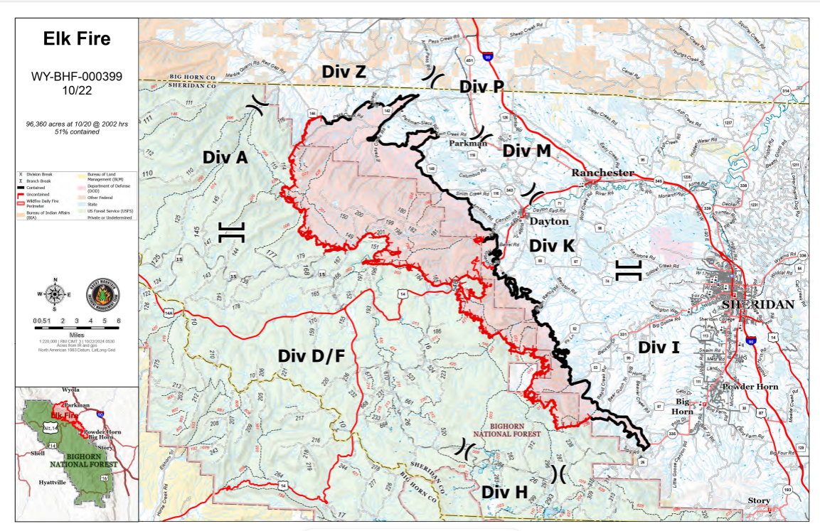
Size: 96,360 acres | Containment: 51%
Rocky Mountain Complex Incident Management Team 1
Dan Dallas, Incident Commander
Special Notes: Evacuations and closures will continue to evolve on the Elk Fire as additional progress is made. Please continue checking the evacuation and closure links below for the most current information.
The Elk Fire Incident Command Post will be moving this week to the Fairgrounds in Sheridan. There may be more firefighter traffic on the highways as a result. Please drive with caution.
Current Situation: Steep terrain and heavy dead and down timber within the fire area make it difficult for firefighters to safely engage the fire. Remnants of snow remain in some of the shaded areas and northern facing slopes; however, a gradual drying pattern continues. Fire personnel were busy yesterday doing prep work to make potential firelines more defensible and repairing previous suppression lines.
Division A: This remote part of the fire with limited access is being surveilled by aircraft and is a lower priority for action at this time.
Division Z: New division management arrived yesterday. Their time was focused on structure protection plans for the area. Crews are continuing to improve firelines in the Red Canyon area. A road grader worked yesterday on suppression repair of dozer lines.
Divisions Z, P, M, K: Graders will continue line prep and repair where appropriate. Heavy equipment is scheduled to arrive on Division K to begin repair work there today. A UAS (drone) was utilized in Division M to identify hot spots.
Divisions I: Ninety percent of suppression repair in this division has been completed on the previously mapped dozer lines. Crews are finding additional dozer lines not shown on maps that they are also repairing as they find them. Crews made good progress on clearing ladder fuels along roads in the southern part of the division.
Division H: Crews are continuing work on the 26, or Red Grade Road, prepping it to use as an indirect fireline, to its junction with the 16 Road. They will prep that road to its junction with Highway 14. This work includes removing brush and other fuels by limbing trees and removing understory vegetation to eliminate small ladder fuels. This will assist with defending firelines in the event fire activity increases. Dozers are establishing areas to stack all the large, removed materials so they are not near the improved firelines.
Divisions D, F: Fire supervisors are searching for hot spots with aerial resources, including drones. They assessed the road system for a potential indirect fireline north of Burgess Junction to protect the WYDOT compound and the Forest Service Visitor Center and Work Center. Good progress was made to prep the 15 Road north to Division A, limbing trees and removing small ladder fuels. Road graders are clearing the snow remaining on the roads, making way for crews and heavy equipment.
Weather, Fuels, and Fire Behavior: Snow from the recent weather system has mostly melted away, except in some areas with north-facing slopes and dense canopies. A drying trend has led to reduced fuel moisture; however, pockets of heat still persist, resulting in creeping and smoldering fire behavior. Individual trees are igniting occasionally due to ladder fuels extending into the tree canopy.
A couple of weak disturbances later in the week will displace the high-pressure system that’s been hovering over the fire. This morning there is a 20% chance of measurable rain, ushered in by some 20-25 mph winds before the front. This should decrease the temperatures, shift the winds to northwesterly and improve minimum relative humidity levels.
We had excellent humidity recovery overnight at about 90%, which will help with firefighting efforts today. It will warm up a little Wednesday before the next front comes through that evening. That front brings a 20% chance of wetting rain across the fire with cooler temperatures.
The cloud cover expected today will minimize fire activity; however, firefighters are aware that flareups could be seen where the expected winds align with fuels and topography.
Evacuations: For information on Johnson County evacuations, go to Johnson County Emergency Management’s Facebook page: https://www.facebook.com/JohnsonCoWYEMC. For info on Sheridan County evacuations and road closures, go to the Sheridan County Emergency Management website: www.tinyurl.com/2s38bcc5. You can also call the Sheridan County Sheriff’s Office (307-672-3455) or Sheridan County Emergency Management (307-752-2174).
Closures: A Temporary Flight Restriction is in place over the Elk Fire. Wildfires are a no-fly zone for unauthorized aircraft, including drones. If you fly, we can’t. For more information, visit http://knowbeforeyoufly.org.
There have been no changes in road closures within the fire area. US Highway 14 is closed between Burgess Junction and Dayton primarily due to falling rocks and debris, and pockets of active fire behavior. There are also closures on Red Grade Road and County Road 89 from Dayton to Beckton Junction. County Road 335 is closed from the intersection of County Road 335 and Brinton Road to the west.
View the Wyoming Department of Transportation road-closure map here: https://www.wyoroad.info/. Bighorn National Forest closure Order No. 02-02-06-24-08 is in effect. The order and map can be viewed here: https://www.fs.usda.gov/alerts/bighorn/alerts-notices.
Elk Fire Information —
Information Phone: 307-303-7642
Hours: 8 a.m. to 8 p.m.
Email: 2024.Elk@firenet.gov
InciWeb: https://inciweb.wildfire.gov/incident…/wybhf-elk-fire-2024
Facebook: https://www.facebook.com/bighornnf
Information Linktree: https://linktr.ee/2024ElkFire

